

It can sometimes be difficult to find your way on a ski slope. Especially if it’s long and winding. But don’t worry, there are several tools available to help you find your way on ski slopes.
This information applies to ski slopes in France. Each country has different tools, signage, and markers.
There’s no point in having the best alpine skis if you can’t find your way around the slopes!
[steps]
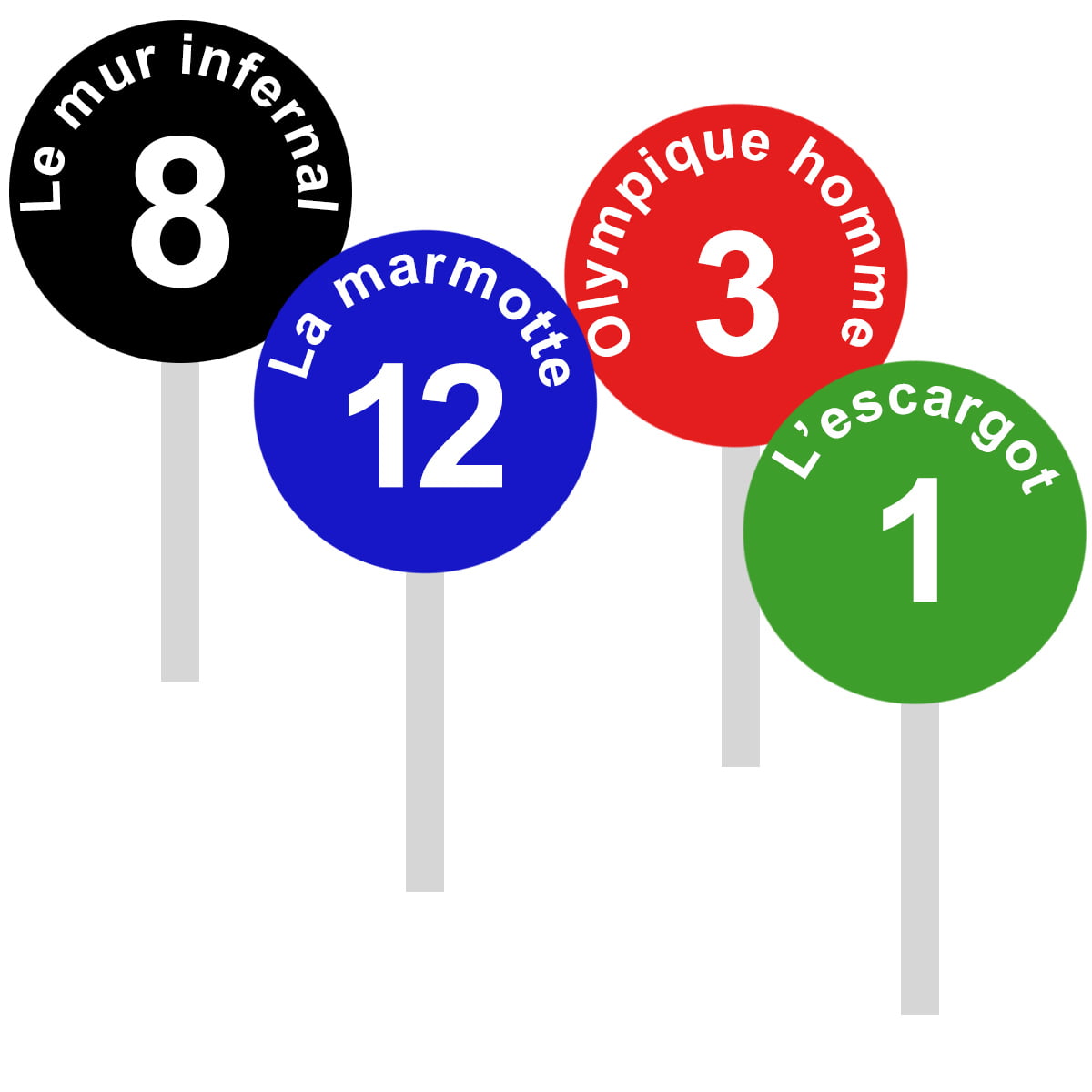
The Markers
- Round signs on the sides of the slope
- Each has a unique number
- Color corresponds to the difficulty of the slope
Markers are traditionally round signs placed along the edges of all ski slopes. Each slope has its own name, so it’s easy to follow a trail by checking that the markers posted along the way always show the same trail name!
In addition, markers have a number. This number isn’t random; it shows how many markers you have left before reaching the bottom of the slope.
If you see the number 1, it means you’re at the end of the slope, or close to it. A higher number means there are still that many markers to pass before reaching the end.
The number is therefore an indicator of the slope’s length. It’s also a way for skiers to find each other if separated.
The markers are colored according to the slope’s difficulty.
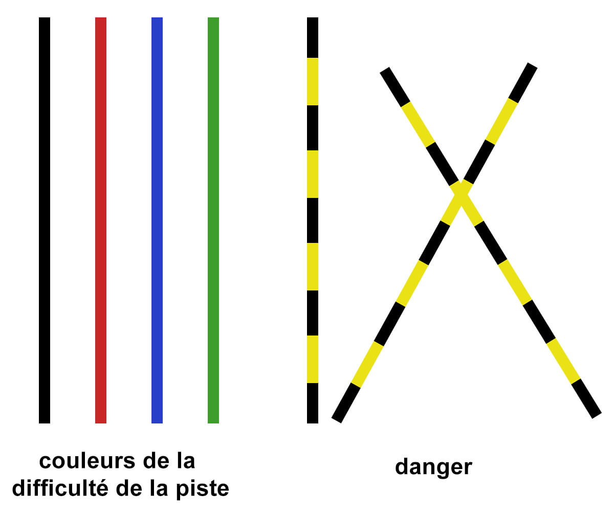
As a reminder, ski slopes in France are classified into 4 groups from easiest to most difficult:
- The green slope 🟢
- The blue slope 🔵
- The red slope 🔴
- The black slope ⚫️
In Canada for example, the markings are different, with diamond rankings:
- Single diamond ♦
- Double diamond ♦♦
- Triple diamond ♦♦♦
The Poles
- Regularly spaced along the slopes
- Same color as the slope difficulty
- Or black and yellow to signal danger
Poles are simply stakes planted in the snow along the slopes. They’re the same color as the slope you’re on. For example, blue stakes for a blue slope.
They are very useful in foggy conditions. They’re usually spaced 5 to 15 meters apart. When it’s snowing heavily and the fog is thick, it becomes almost impossible to find your way. All visual landmarks disappear, and skiers often get lost, even just a few meters away from the slopes.
In addition to the poles colored according to the slope,
there are also black and yellow poles 🟨 ⬛️ used to indicate a hazard.
For example, exposed rocks on the slope, an ice patch, or cliffs nearby. Dangers are generally well marked both on and around the slopes.
However, hazards can also appear during the day after the ski patrol has already made their rounds. New rocks or ice patches appearing throughout the day are common.
So stay vigilant—markers, poles, and signs are great safety tools, but you are your own best asset to spot dangers, especially when the weather is unstable or changing.
The Trail Map
- Shows all the trails
- Paper format recommended
- Don’t rely solely on your phone’s GPS
Nothing beats a good trail map for finding your way.
I can already hear you: « I’ll just whip out my smartphone to geolocate myself… » Well, yes and no.
In the mountains, GPS signals aren’t always reliable, they can be partial or bounce off cliffs, causing bad localization. Plus, with fluctuating GPS signals and cold temperatures, your phone battery will drain very quickly.
The solution? Keep a paper trail map in your pocket. It’s a great backup to have on you for peace of mind.
On top of that, ski resorts often have large trail maps posted at the bottom and top of lifts. It’s a good time to get your bearings before heading down the slope.
Quel ski choisir pour un bon skieur ?The Surrounding Geography
- Observe the surrounding mountains
Being observant is an undeniable advantage in the mountains. The rugged environment means you’re surrounded by recognizable and distinctive peaks.
Familiarizing yourself with the surrounding mountains and terrain could be a huge help if you ever lose your map, your phone dies, and no one is around.
Elevation Gain
Elevation gain is an important factor, and it’s usually indicated on slope maps. If the elevation gain is very steep over a short distance, the slope will likely be challenging and the terrain rugged.


Your comments and questions